Quenomica Preserve
Size
6.6 acres (Quenomica Preserve North)
20.8 acres (Quenomica Preserve South)
Description
Perhaps the most isolated site on Martha's Vineyard Island.
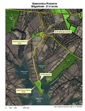
Fittingly, it requires effort. One reaches Quenomica Point, the tusk of the Quenomica peninsula, after about a mile of rambling through pasture, wild meadow, a little neighborhood and some coastal oakland. Hikers park at a trailhead on the Meetinghouse Way, abutting the land bank headquarters, and then begin their trek --- but one universal access parking spot is located on the peninsula for visitors requiring more proximate access. Although two-thirds of a mile of shoreline is conserved here, along the Meshacket and Wintucket Coves of the Edgartown Great Pond, the limbic spot is the austral one: water, and solitude.
Access
Start at the intersection of the West Tisbury Road and Meetinghouse Way. Travel down Meetinghouse Way 0.45 miles and turn right into the land bank driveway; make a horseshoe to the left to enter the trailhead.
For universal-access visitors, start at the intersection of the West Tisbury Road and Meetinghouse Way and travel down Meetinghouse Way 0.5 miles. Turn right onto Kanomika Road and find trailhead 1.0 miles later.
Kayakers are welcome to land on the peninsula's easterly shore, just opposite the town boat launch at Wilson's Landing.
Historical Highlights
Quenomica derives from the Wampanoag word Quanamaukeag, meaning "long fishing place" or "long eel fishing place"
In the early 20th century the South preserve was occupied by the Quenomica Shooting Club, which enjoyed proximity to the duck flyways on the Meshacket and Wintucket Coves.

