North Neck Highlands Preserve
Dog Policy
Size
4.9 acres
Description
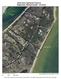
North Neck, narrow and tall, rises out of the Nantucket Sound and Cape Poge Pond. The land bank has informally dubbed this property “The Map,” since from its heights hikers easily observe the region’s geography: the curve of the Cape Poge Elbow, Martha’s Vineyard’s east shore (with West Tisbury’s Indian Hill in the distance) and the far-off islands of Nantucket County. Two beaches are visible: on the west is the Cape Poge Gut beach, popular for fishing (as all of the Cape Poge Pond drains through it), and on the east is the Cape Poge Pond beach, which has a barren quality. This land is a fallout site for tired birds and butterflies migrating south across the sound, affording excellent wildlife viewing
Universal Access
- Difficulty rating: Moderate
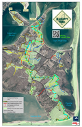
- Trail: 200’ of hardened trail, located on the east side of the North Neck Road, to bench and viewing platform
- Points of Interest: Viewing platform with bench offers pond views.
- Benches: 1
Access
Turn left off the Chappaquiddick Road onto the North Neck Road 1.3 miles past the ferry slip; preserve is on the left 1.1 miles up the North Neck Road. Trailhead is located here; a second trailhead is located 0.1 farther up the road on the right.
Historical Highlights
- North Neck was blocked out as a common setoff for the Wampanoags and remained same until 1850, much longer than anywhere else in Edgartown


