Hillman’s Point Preserve
Dog Policy
Size
2.2 acres
Description
The pines on this land are typical Tashmoo — thick and shady. This contrasts sharply with the land’s sand spit which projects into the pond: it is a plein air setting where the sun and especially the wind are intense.
Universal Access
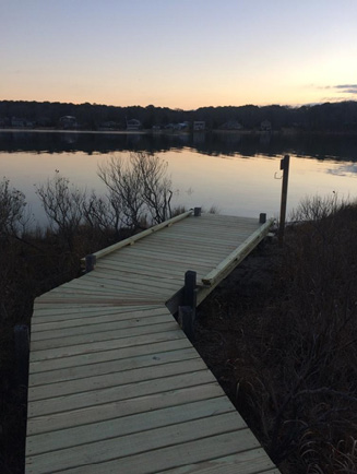
- Difficulty rating: Moderate
- Trail: 250’ of hardened trail and 150’ of raised boardwalk
- Points of Interest: Offers shoreline access from boardwalk platform and views of Lake Tashmoo
- Benches: 0
Access
Start at the intersection of the State Road and Lower Lamberts Cove Road in Tisbury. Proceed up the Lamberts Cove Road 0.3 miles to its intersection with the Northern Pines Road; turn right onto the Northern Pines Road and proceed past signs reading “Private” and “No Water Access.” Continue 0.5 miles until the road forks; take the right fork. Travel 0.4 miles to where the road divides again; continue straight here. After 0.1 miles turn right and then continue another 0.1 miles to the land bank trailhead. Parking and access are limited and visitors may have to be turned away; please have an alternate destination in mind if you are planning a trip to this property.
Historical Highlights
- Lake Tashmoo is naturally a freshwater pond but the 1938 hurricane breached the barrier beach and opened the pond to the salt water of Vineyard Sound; it readily filled with clams and scallops, prompting townspeople to dredge the channel and maintain it as a salt-pond
